CPI SAT RC3000 Satellite Locator & Inclined Orbit Tracking Antenna Controller System


Calculates azimuth & elevation angles from any position and heading, Precisely positions antenna with the press of a single key, automatic stowing
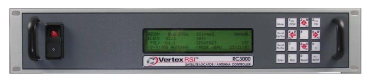
RC3000 Mobile VSAT Controller
The CPI SAT (formerly GD Satcom Technologies & Prodelin) RC3000 Antenna Controller System is an antenna controller designed for use with mobile satellite uplink vehicles and flyaway systems. The 3000 series antenna controller system is able to calculate the azimuth and elevation angles required to align the antenna with a satellite. To determine the antenna pointing solution the controller has to know the magnetic heading of the uplink vehicle (or platform), the latitude and longitude of the uplink site, and the longitude of the satellite. Heading data can be provided by the optional flux gate compass. The latitude and longitude of the uplink site can be determined with the optional GPS receiver.
AUTOMATIC LOCATION OF SATELLITE
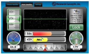
In LOCATE mode, azimuth and elevation pointing angles are automatically calculated based on position (lat/lon), heading and the selected satellite. Position may be obtained automatically from the optional GPS, selected from a preset list of user defined positions or entered manually. Heading may be automatically obtained from the optional fluxgate compass or entered manually. The user selects which satellite to locate from either a preset user defined list or by manually entering satellite data. The CPI Satcom RC3000 series controller checks that the pointing solution is within the mount’s range of movement and automatically positions the antenna.
PHYSICAL
Size: 19.0” x 3.5” x 17.0” (rack)
Weight: 20.0 lbs. (A model), 18.0 lbs. (B model)
Temperature: 0o – 50o C
Input Power: 115/230 VAC: switchable (A model),
specify input power when ordering
(B model), 50/60 Hz., 50 W idle, 850 W
when moving – CE compliant
Display: 4 x 40 LCD
INTERFACES
Position: Elevation inclinometer, azimuth &
polarization potentiometers, azimuth &
elevation pulse sensors (Reed, Hall Effect,
Optical), discrete limit switches
Serial: RS-422/RS-232 (GPS, fluxgate, remote control)
AGC Input: -15 to +15 VDC input range, 2MΩ input
Output: 12-36 VDC motor drive (A model)
90 VDC motor drive, 180 optional (B model)
Automatic Pointing Solution
Calculates azimuth & elevation angles from any position and heading
Optional GPS Receiver
Battery backup for fast position fix, one pulse per second clock synch pulse
Optional Fluxgate Compass
Calibrate by driving in circle
Automatic Positioning
Precisely positions antenna with the press of a single key, automatic stowing
Inclined-Orbit Tracking
Step Track, Memory Track & Intelli-Search modes
Polarization Control
Automatic or manual control for rotating feeds with potentiometer feedback
Non-volatile Memory
Store position and polarization data (including inclined orbit track data) for 50 satellites
Automatic Recall of Stored Satellites
Inclined orbit tracking automatically initiated